Why a Database Management System (DBMS) Is the Superior Choice Over a Geographic Information System (GIS) for the County Surveyor’s Office
Section Corner Perpetuation: Why a Database Management System (DBMS) Is the Better Primary Tool
“A GIS displays information —
The database is the system of record; the map is the window.”
The underlying information that gives a GIS meaning — records, attributes, documents, and historical context — must exist in a structured database. Without that data, a GIS map is nothing more than a picture.
For the County Surveyor’s Office, the legally mandated responsibility is not to produce maps, but to maintain, preserve, and dispense authoritative records related to section corners and land surveys. That responsibility requires a system designed to manage data, history, and documentation — which is the role of a Database Management System (DBMS).
A GIS can then consume that data to provide mapping and public visualization, but it should not replace the database as the system of record.
Why a Database Management System (DBMS) Is the Superior Choice Over a Geographic Information System (GIS) for the County Surveyor’s Office
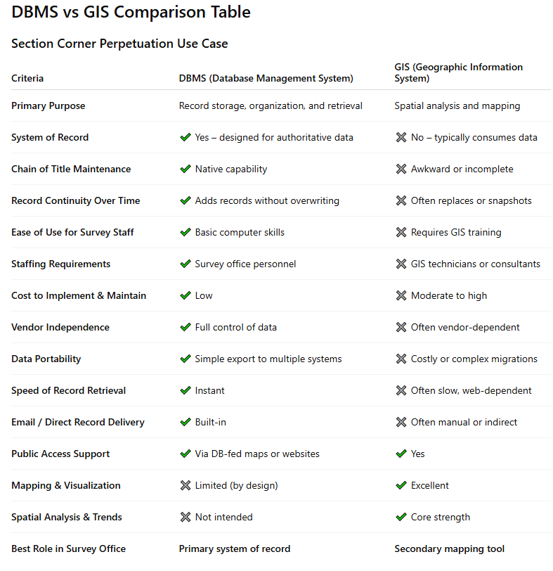
County Surveyors are statutorily responsible for the perpetuation, maintenance, and dissemination of section corner records. To meet this responsibility effectively, the tools used must support record continuity, long-term preservation, public access, and administrative control — all within realistic county budgets.
While Geographic Information Systems (GIS) play an important role in county government, GIS is not well suited to serve as the primary system of record for section corner perpetuation. A Database Management System (DBMS) remains the most appropriate and cost-effective solution for this specific responsibility.
Core Requirements
To properly fulfill section corner duties, the County Surveyor’s office must be able to:
Maintain a permanent chain of title for each corner
Add records over time without overwriting historical data
Digitally archive survey records in a stable format
Retrieve and dispense records quickly to surveyors and the public
Operate independently of specialized technical staff
Retain control of records regardless of GIS vendor changes
Function within the financial realities of all counties
Why a DBMS Is the Better Fit
A DBMS is purpose-built to store, organize, and retrieve structured records. It allows section corner records, plats, legal surveys, notes, and related documents to be maintained in one system, with immediate access and long-term continuity.
A properly designed DBMS:
Requires only basic computer skills to maintain
Preserves record history without data loss
Allows immediate emailing or digital delivery of records
Keeps the County Surveyor in direct control of their records
Can export data to GIS or public mapping platforms as needed
Limitations of a GIS-Centered Approach
GIS excels at spatial analysis, routing, and visualization, but these capabilities are not central to section corner research. Using GIS as the system of record often:
Increases cost through consultants and specialized staff
Slows record retrieval
Limits flexibility when GIS vendors change
Shifts control of Surveyor records to non-Surveyor personnel
Conclusion
A Database Management System should serve as the system of record for section corner perpetuation. GIS should function as a downstream mapping and visualization tool, not the primary repository.
This approach provides the best balance of efficiency, cost control, data integrity, and public service — while preserving the authority and responsibility of the County Surveyor’s office.